My second posting under ‘Legends’ is: The Tale of Ravouvou and Raluve iVanuakula. Like my first legend, this too, has a connection to volcanoes and aspects of climate change.
Vanuakula Island, like all other Astrolabe Islands, is volcanic.[1] The southeast coast of the island, for example, represents the steeper inner wall of the original caldera formed from the volcanic eruptions of the two volcanic centres on Dravuni. The caldera has since been largely submerged.
Caldera is a large cauldron-like hollow that forms shortly after the emptying of a magma chamber/reservoir in a volcanic eruption. When large volumes of magma are erupted over a short time, structural support for the rock above the magma chamber is lost.
The same southeast coastline also displays signs of a fault running northwest-southeast. A fault is a fracture or discontinuity in a volume of rock across which there has been significant displacement as a result of rock-mass movement. This fault may also account for the existence of the nearby Usborne and Herald Passes through the Astrolabe Reef. These passes are respectively: the Daveta iVanuakula and Daveta iNamara. Furthermore, this same fault may also account for the formation of the bay to the north of the island, giving it a heart shape to add to its charm.
The 1992 Study (see Footnote) inferred from its research that there was also an independent volcanic centre now submerged to the north east of the island – not far off the coastline. The general northeast-southwest trending of the dykes found across the island points to the existence of such a centre.
A dyke is formed when magma from the volcanic centre fills up cracks in pre-existing rocks and it solidifies and becomes a rock itself. Sometimes, the crack would fill up with sedimentary rocks and solidifies also over time. The latter type of dyke can be subject to erosion at a later stage.
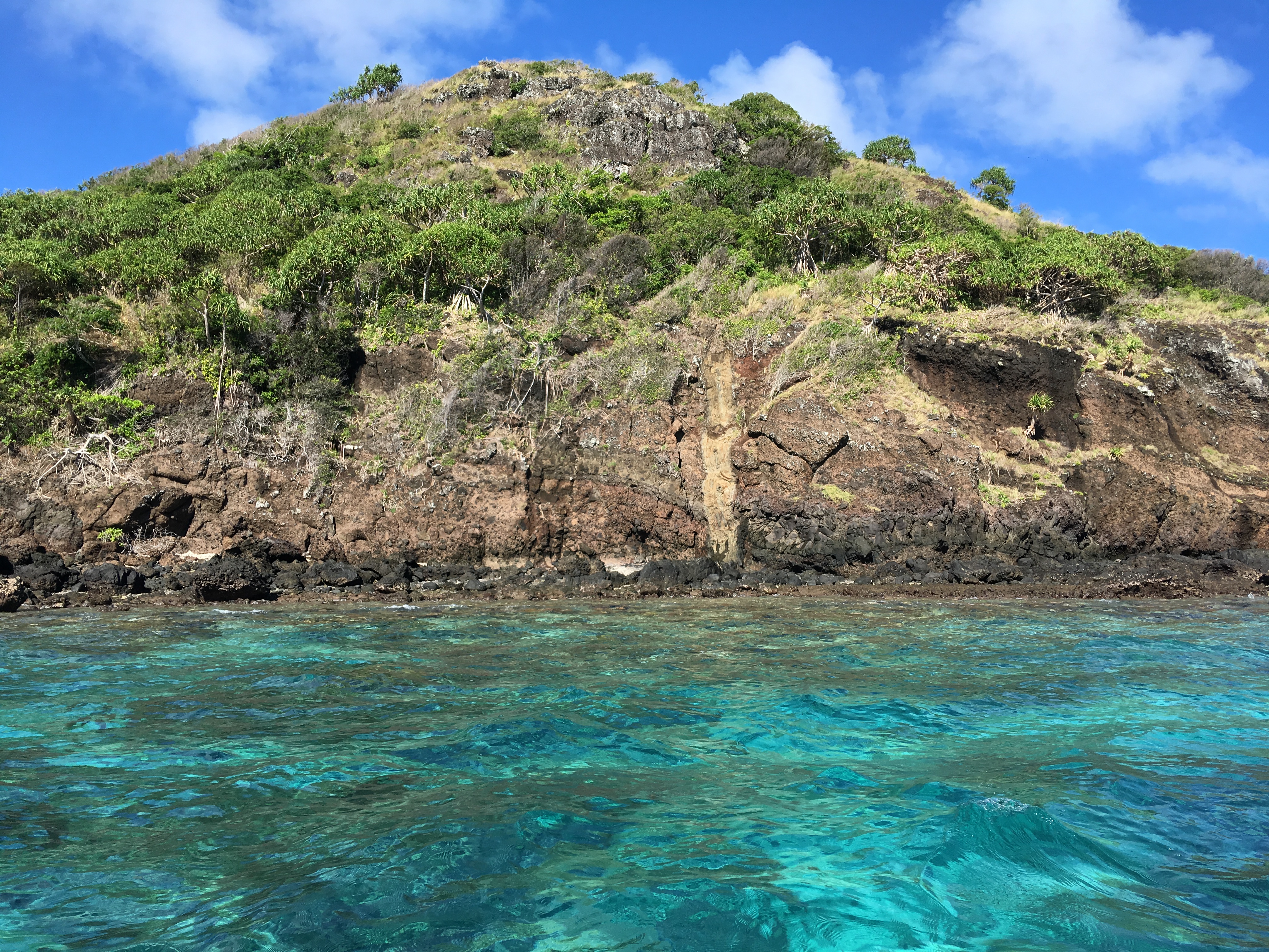
The dyke formation that is specifically linked to the legend is that in the picture above. This is put down in the legend as the final scratch mark made by Raluve iVanuakula’s fingernails as she was being dragged by the Tongan warriors who were forcibly taking her to Tonga to be the bride of the Tongan prince.
This particular dyke is located on the east/northeast coast of Vanuakula that is directly bordering the inferred volcanic centre, linked to the island and facing the Solo Reefs. Whilst dykes have a greater resistance to erosion, generally speaking, this specific one is displaying signs of natural wear and tear. The same Study points to the prospects of erosion and the impact attributable to a relatively high sea level.
Whilst volcanic activities took place well before human habitation,[2] it is possible that the erosive processes of the said dyke could have happened much much later and thus witnessed by the recent inhabitants of Vanuakula and/or Dravuni. It can be imagined that the rarity of the event and its visual transfiguring phases over time were sufficient motivation for the storytellers to weave their interpretive narratives.
The narratives would have been further fuelled by the knowledge that the dykes across the island invariably radiate northeast-southwest from the inferred volcanic centre. Their uniform multiplicity and unidirectionality can be uncanny. But not so to our ancestors. They were scratch marks! And clear signs of the immensity and intensity of the struggle by Raluve iVanuakula. They were also signs of the determination of the Tongan warriors to drag their dauntless captive, regardless of the terrain, towards their waiting canoe.
[1] See “Fiji’s Great Astrolabe Reef and Lagoon: A Baseline Study, edited by R.J. Morrison and Milika R. Naqasima, 1992.
[2] From the same Study above: “….volcanic activity…ended before the beginning of the Quaternary, some 1.8 million years ago.”

One Comment Add yours